

Imray C3 Isle of Wight
£23.36
In Stock1 in stock (can be backordered)

Description
Imray Chart C3 Isle of Wight
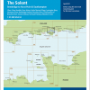
A passage planning chart ideal for sailing near or around the Isle of Wight. This chart has been reschemed to better complement the other folded charts in our Solent chart range (C15, Y33). Coverage has been adjusted to show the full circumnavigation of the Isle of Wight including the south coast passage. Inset plans of the Needles Channel and Bembridge Harbour and approaches are included.
The latest official UKHO data is combined with additional information sourced from Imray’s network to make it ideal for small craft.
New: Vessel Traffic Services (VTS) reporting points
Imray charts for the Solent and approaches now include all VTS reporting points found in these waters. VTS reporting is mandatory for vessels of more than 20m in length that are bound to and from the Solent.
Plans included: Needles Channel (1:35 000)
Bembridge Harbour & Approaches (1:10 000)
The chart is designed to be used alongside C15 The Solent for combined coastal navigation, approach, and harbour detail in and around the Solent and Isle of Wight.
Additional information
| Weight | 0.5 kg |
|---|---|
| Dimensions | 30 × 25 × 1 cm |
| Edition Date | March 2024 |
| Scale | 1:100 000 WGS 84 |
Related Products
-
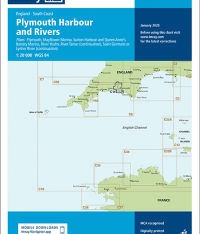
Plymouth Harbour and Rivers
£23.36 -
 £23.36
 -
 £23.36
 -
 £23.36
 -
 £23.36
 -
 £23.36