-
×
 474 - Port of Spain and Approaches
1 × £37.80
474 - Port of Spain and Approaches
1 × £37.80 -
×
310 - Angola and Nambia Ponta Grossa to Kunene River
1 × £37.80
Subtotal: £75.60
 474 - Port of Spain and Approaches
1 × £37.80 310 - Angola and Nambia Ponta Grossa to Kunene River
1 × £37.80
474 - Port of Spain and Approaches
1 × £37.80 310 - Angola and Nambia Ponta Grossa to Kunene River
1 × £37.80 Subtotal: £75.60
£37.80
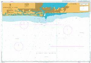
In StockApproaches to Lagos
Admiralty Chart 1381 Approaches to Lagos
All our standard charts are corrected to the latest Notices to Mariners and available as POD.
| Weight | 0.121 kg |
|---|---|
| Dimensions | 88 cm |
| Edition Date | 15/05/2025 |
| Publisher | UKHO |
| Author | Admiralty |
Brazos Santiago to Galveston Bay
Cabo Roxo to Monrovia
Baia dos Tigres
Angola, Cabo Ledo to Lobito
Gambia to Luanda
Senegal, Approaches to Dakar, Baie de Goree
