-
×
 979 - Indonesia Jawa North Coast Selat Surabaya Sheet 3
1 × £37.80
979 - Indonesia Jawa North Coast Selat Surabaya Sheet 3
1 × £37.80 -
×
1185 - England East Coast River Thames Sea Reach
1 × £37.80
Subtotal: £75.60
 979 - Indonesia Jawa North Coast Selat Surabaya Sheet 3
1 × £37.80 1185 - England East Coast River Thames Sea Reach
1 × £37.80
979 - Indonesia Jawa North Coast Selat Surabaya Sheet 3
1 × £37.80 1185 - England East Coast River Thames Sea Reach
1 × £37.80 Subtotal: £75.60
£37.80
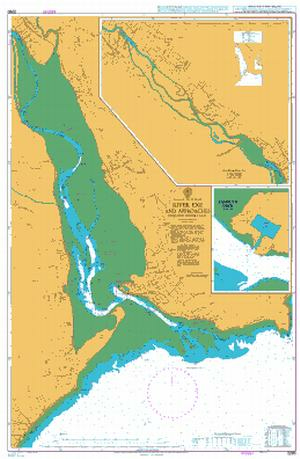
In StockEngland – South Coast, River Exe and Approaches including Exeter Canal
Chart 2290 River Exe and Approaches including Exeter Canal
All our standard charts are corrected to the latest Notices to Mariners and available as POD. Please contact us if you would prefer this in POD (print on demand) format.
| Weight | 0.121 kg |
|---|---|
| Dimensions | 88 cm |
| Edition Date | 17/10/2024 |
| Publisher | UKHO |
| Author | Admiralty |
British Isles, Approaches to the Bristol Channel
Plans on the Coast of Somerset and Devon
North West Approaches to the Orkney Islands
Bristol Channel
Northern Approaches to the Shetland Islands
British Isles, Orkney and Shetland Islands
