
EC1 Meridian Chart Pack USB

£165.00 ex VAT
In StockAvailable on back-order

Description
EC1 Meridian Chart Pack USB
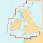
This chart pack contains over 860 raster charts covering the UK and Ireland. This product has been derived in part from material obtained from the United Kingdom Hydrographic Office.
Included within the Chart Pack
- Charts covering the United Kingdom and Ireland
- Chart plotter for both passage planning and navigation
- 12 months subscription to the Meridian Chartware Update Service
- 12 months tidal data including ports and streams
- European wreck database
Updates
This product includes 12 months subscription to the Meridian Chartware Update Service, which includes
- Annual tidal port and stream updates
- Quarterly updated wreck database
- Quarterly chart updates
- Weekly notice to mariners
- Software updates
At the end of your subscription you have the option to renew at a reduced rate, however should you not wish to continue with the Meridian Chartware Update Service you would only lose the subscription features but retain access to the chart plotter and charts.
ncluded with your purchase of this chart pack is a choice of two chart plotters both fully featured which can be used for both planning and navigation.
Our chart plotters enable you to plan your route at home, using tidal information to work out the best time to leave. You can then transfer the route to your laptop to use as a real-time navigation system on board your vessel. They are feature-rich, the main ones are as below
NMEA Inputs
- AIS support
- GPS support
- ARPA support
- Garmin GPS compatible
- Gyro support
NMEA Outputs
- NMEA output including messages to an autopilot
Navigation
- Display vessel position on chart using GPS
- Display projected track of vessel. Based on time and speed
- Overlay AIS targets on charts and display individual projected tracks
- Man overboard
- Configurable alphanumeric navigation information display
- Display vessel heading using Course Over Ground or Gyro
- Dimmable display for use at night, twilight or day
- Log your position to a file and show vessel snail trail on chart
- Follow vessel through charts with automatic chart swapping
- Multiple window display, allows different charts to be shown simultaneously
- Change format of geographical display
- Full screen mode for complete screen view of chart
- Set limit for cross track error
- Course to steer
Passage Planning
- Print charts with overlays
- Create and overlay waypoints with selectable symbols
- Create and overlay routes with a detailed passage plan containing:
- Leg distance
- Leg time
- Time of departure and arrival
- Total distance and time
- Tidal set / drift and gain
- Course to steer
- Bearing
- Best time to depart using tidal data
- Reverse route
- Overlay boundaries onto chart with option to alarm on entry or exit
- Zoom by chart scale or pixel
- Overlay Notice to Mariners
- Magnetic variation data
- Transfer waypoints to GPS unit
- Input your vessel clearance for use with tidal information
- Find position on chart using geographical coordinates
Tides
- Ability to print tide tables
- Tidal ports with curves
- Overlay diamonds / real time arrows and streams on charts
Wrecks
- Overlay wreck database which contains over 70,000 wrecks and obstructions
- Search for wreck by name, date or by area on chart
- View detailed information from each wreck such as:
- Vessel and cargo information
- Position
- Seabed
- Survey
- History
- Charting
Additional information
| Weight | 0.5 kg |
|---|---|
| Dimensions | 25 × 10 × 1 cm |