-
×
 Speed Time Distance Calculator
1 × £10.00
Speed Time Distance Calculator
1 × £10.00 -
×
Captain Fields' Pattern 400mm Parallel Rule
1 × £42.00
Subtotal: £52.00
 Speed Time Distance Calculator
1 × £10.00 Captain Fields' Pattern 400mm Parallel Rule
1 × £42.00
Speed Time Distance Calculator
1 × £10.00 Captain Fields' Pattern 400mm Parallel Rule
1 × £42.00 Subtotal: £52.00
£10.00 ex VAT
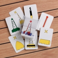
In StockThe IALA region A playing card size flip cards provide a very easy learning platform and are ideal for swatting up on your buoyage.
Available on back-order
IALA Buoyage System Cards “A”
All mariners need a comprehensive knowledge of the buoyage rules and should be able instantly to identify a mark at first sight. These Flip Cards show 31 different buoys and navigational marks in colour, with the meaning and position, together with the light characteristics on the back of the card. Both the Cardinal and IALA marks are featured, as well as the more recent preferred channel buoys. This set shows the ‘A’ Region buoys which are found in most areas of the world.
Also a useful guide for students.
31 cards in the pack.
| Weight | 0.082 kg |
|---|---|
| Dimensions | 11 × 8 × 1.5 cm |
You must be logged in to post a review.
Staedtler 2B Pencil
The cards show equipment and procedures for HF, VHF and MF, including Digital Selective Calling. Playing card size flip cards provide a very easy learning platform and are ideal for revision.
The CEVNI playing card size flip cards provide a very easy learning platform and are ideal for swatting up on CEVNI signs and symbols.
200mm set square features protractor markings and compass points with reciprocals in red, the scale is in millimeters.
This simple to use slide rule from Blundell Harling calculates the third variable given the other two (i.e. distance covered, given speed and elapsed time).
600mm, Captain Fields’ pattern parallel rule is divided with protractor markings (double reading) and compass points.

Reviews
There are no reviews yet.