-
×
 5124(12) - Routeing Chart North Atlantic Ocean - December
1 × £19.08
5124(12) - Routeing Chart North Atlantic Ocean - December
1 × £19.08 -
×
Imray Chart C56 Cork Harbour to Dingle Bay
1 × £28.95
Subtotal: £48.03
 5124(12) - Routeing Chart North Atlantic Ocean - December
1 × £19.08 Imray Chart C56 Cork Harbour to Dingle Bay
1 × £28.95
5124(12) - Routeing Chart North Atlantic Ocean - December
1 × £19.08 Imray Chart C56 Cork Harbour to Dingle Bay
1 × £28.95 Subtotal: £48.03
£28.95
In Stock1 in stock (can be backordered)
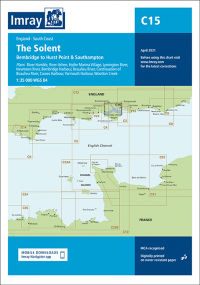
Imray Chart C15 The Solent
Covering one of the most popular sailing areas in Britain, The Solent chart provides all the information needed for planning and navigating this stretch of water.
This edition includes the latest official data from the UKHO combined with additional information sourced from Imray’s network to make it ideal for small craft.
New: Vessel Traffic Services (VTS) reporting points
Imray charts for the Solent and approaches now include all VTS reporting points found in these waters. VTS reporting is mandatory for vessels of more than 20m in length that are bound to and from the Solent.
The latest racing buoy information is included and the chart has been fully revised throughout.
Plans included: River Hamble (1:12 500)
River Itchen (1:12 500)
Hythe Marina Village (1:12 500)
Lymington River (1:15 000)
Newtown River (1:20 000)
Bembridge Harbour (1:10 000)
Beaulieu River (1:20 000)
Continuation of Beaulieu River (1:20 000)
Cowes Harbour (1:20 000)
Yarmouth Harbour (1:4500)
Wootton Creek (1:20 000)
| Weight | 0.5 kg |
|---|---|
| Dimensions | 30 × 25 × 1 cm |
| Edition Date | Mar-24 |
| Scale | 1:100 000 WGS 84 |
