
30
May
May Newsletter
!NEWS!
Welcome to our May Newsletter
NEW EDITIONS JUST PUBLISHED
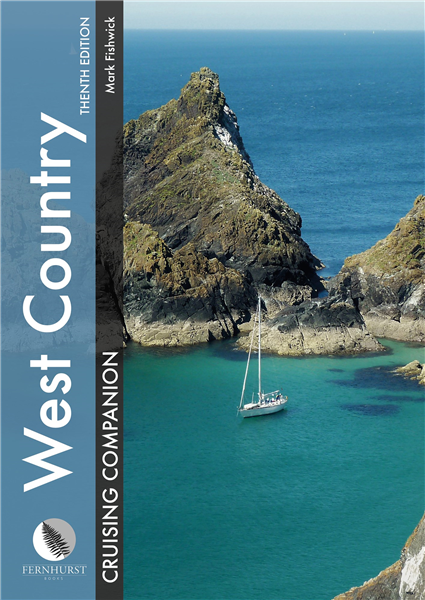
West Country Cruising Companion
The go-to West Country pilot guide since 1988, now updated for its tenth edition.
Mark Fishwick’s West Country Cruising Companion is the leading pilot guide to this wonderful cruising area of south west England. First published in 1988 as West Country Cruising, it is now in its tenth edition. It remains in hardback (and eBook) and covers the area from Portland Bill to Padstow, as well as the Isles of Scilly, giving passage information into the area from both the east and the north.
This definitive sailing guide for the ever-attractive coastline of Dorset, Devon, Cornwall and the Isles of Scilly combines a skilful blend of pilotage and cruising information, with historical insight and suggestions of where to eat and what to do ashore.
For those who plan to head west, this book is more than essential reading – it will enhance your enjoyment and prove to be a worthy and much used addition to the ship’s library. Those already in the west will find themselves regularly thumbing its pages.
Share Mark Fishwick’s passion for this region which combines with his in-depth knowledge from a lifetime cruising these waters to create a text which will inspire and inform you. It is enhanced with colour charts and detailed photography, including spectacular aerial shots of many ports, harbours and anchorages.
RRP £42.50
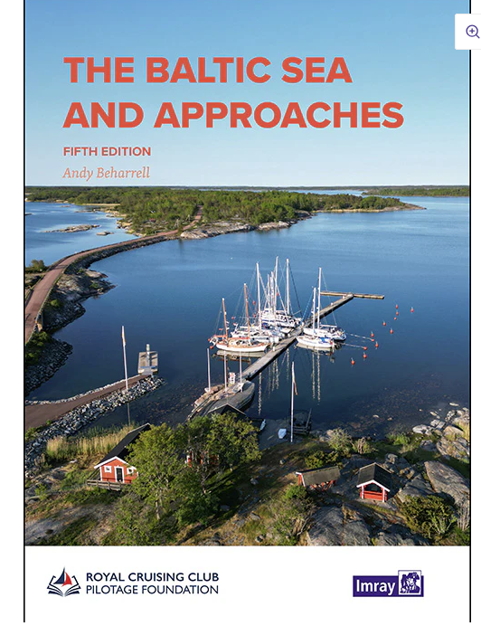
The Baltic Sea and Approaches
This comprehensive volume provides an overview of the Baltic Sea and its approaches from the west for cruising sailors. Thoroughly overhauled by editor Andy Beharrell, much of the text has been rewritten since the last edition, with useful photos and detailed plans updated throughout.
The nine countries bordering the Baltic Sea offer an immense variety of cruising grounds, people and cultures. There are thousands of harbours and innumerable anchorages. The information contained in this book provides edited highlights chosen for their value both at the planning stages and again on arrival, when a general overview of each individual country is followed by specific harbour information.
Where detailed cruising information is readily available – effectively Germany, Denmark, Sweden and Finland – only selected harbours are covered, chosen, with a few exceptions, as fulfilling certain key needs. Where cruising information is more limited – Poland, Kaliningrad, Lithuania, Latvia, Estonia and Russia – many smaller harbours are also featured in detail.
Beautiful, secluded anchorages, picturesque canals, bustling marinas, dramatic cities – all await those considering a Baltic cruise.
RRP £52.50
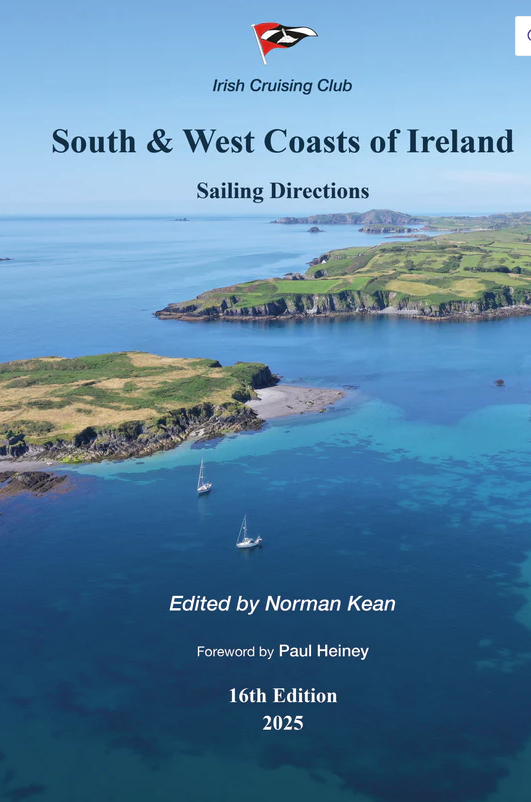
South & West Coasts of Ireland Sailing Directions
The Irish Cruising Club’s Sailing Directions, used and trusted since their first editions in 1930, are the standard work on small-craft pilotage of the coasts of Ireland and are often described as the “bible” for yachts. The books aim to describe every feasible passage, port, harbour and anchorage on the coasts of Ireland, from the point of view of the small-craft skipper.
They are continually updated by amendments on the web, and new editions are published every four to five years. They draw on the experience of generations of amateur and professional sailors. They are also carried by the ships of the Irish Naval Service, the Commissioners of Irish Lights and the Geological Survey of Ireland, and used as the basis of local knowledge manuals at several RNLI lifeboat stations.
RRP £44.50
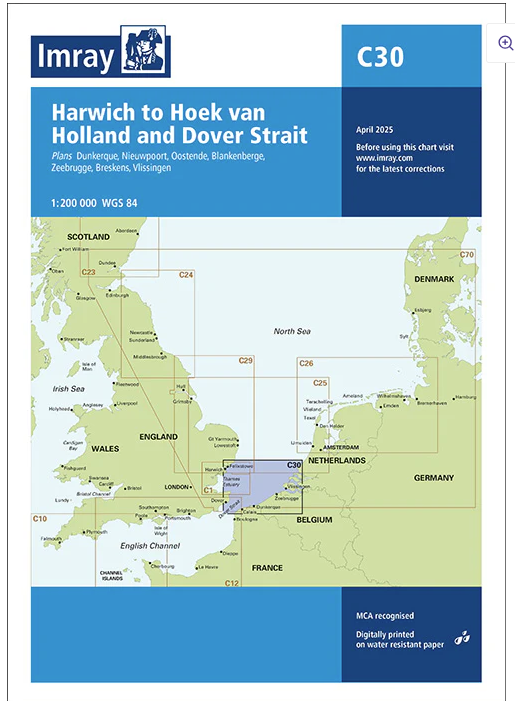
C30 Harwich to Hoek van Holland and Dover Strait
Plans included:
- Dunkerque (1:25 000)
- Nieuwpoort (1:30 000)
- Oostende (1:20 000)
- Blankenberge (1:10 000)
- Zeebrugge (1:35 000)
- Breskens (1:12 500)
- Vlissingen (1:20 000)
New: Vessel Traffic Services (VTS) reporting points
Now includes all VTS reporting points found in these waters.
This edition includes the latest official data combined with additional information sourced from Imray’s network to make it ideal for small craft. It includes the latest official bathymetric surveys and the latest windfarm information.
Suggested routes showing popular passages across the chart have been updated. Further pilotage information on these routes are included in the North Sea Passage Pilot by Garth Cooper published by Imray. There has been general updating throughout.
RRP £28.95
FUTURE NEW EDITIONS
Nories Nautical Tables 2025 Edition
Regardless of the developments in electronic navigation this remains an essential requirement for anyone learning and practising astro-navigation.
Since J W Norie published the first edition of his Complete Set of Nautical Tables and Epitome of Practical Navigation in 1803, many changes to the tables have been necessary in both content and presentation. New tables have been included, obsolete ones deleted to conform with changing techniques of navigation, with the aim of improving the accuracy of the calculated position and reducing the tedium of the calculation. Since the commissioning of the Global Navigation Satellite System (GNSS), its proven accuracy and reliability in all weather conditions have resulted in confidence and almost unquestioning dependence on its ability to provide a vessel’s position, course and speed.
Its use is widespread but the marine environment is a hostile one and failure of electronic equipment or of the system itself is a possibility. No prudent seafarer would proceed on an ocean passage without a reliable navigational back-up. The Explanation is in the form of a detailed step-by-step description, by means of worked examples, of the different methods of performing navigational calculations using a scientific calculator and/or the tables.
A number of esteemed editors have worked on Nories’ Nautical Tables over the years and this edition includes new contributions from Francois Hugo. This edition now presents formulae in an appropriate format for direct entry to a scientific calculator. Because the possibility of navigation without even an appropriate calculator exists, the logarithms have been retained.
All the tables required for coastal and deep sea navigation are included. A simple uniform method of interpolation for all the trigonometrical tables is used. Certain tables and data are also included which are not readily available on board ship or are only used in the examination room.
RRP £45.00
Greek Waters Pilot 2025 Edition
Greek Waters Pilot is the definitive cruising guide to the coasts and islands of Greece, covering the entire area from the Ionian Islands to the Aegean, Rhodes and Crete and includes details of over 450 harbours and anchorages in a single volume.
Greek Waters Pilot has been painstakingly compiled from Rod and Lucinda Heikell’s own survey work and exploration over four decades, as well as first-hand information from their network of contributors. The organisation of so much detail within the confines of a single volume is impressive. This, the fourteenth edition, marks the fortieth anniversary of the first edition of this celebrated cruising guide. It has once again been thoroughly updated to reflect developments and changes across the whole region.
Enriched with fascinating historical, mythological and gastronomic information, Greek Waters Pilot is an incomparable resource and companion for anyone planning to spend time in these endlessly enticing waters.
RRP £55.00
Cruising Guide to the Netherlands and Belgium
Cruising Guide to the Netherlands and Belgium is a new first edition from the Royal Cruising Club Pilotage Foundation, building on Brian Navin’s popular guide which was regarded as the authoritative companion for anyone cruising the Netherlands using fixed mast routes.
The new guide provides a comprehensive overview and pilotage of the coastal ports and the mast-up routes through the heart of the Netherlands. Coverages stretches from Nieuwpoort in Belgium via the Rhine-Maas-Schelde Delta, up the coast of Holland and into the stunning cruising grounds of the Waddenzee to the border with Germany. Additionally, an edited selection of inland routes for yachts covers the rivers and canals of north and south Holland, Friesland and Groningen. The marinas, ports, and waterways of the IJsselmeer, Markermeer and Randmeren complete the volume.
RRP £37.50
Reeds Crew Handbook 2nd Edition
Reeds Crew Handbook is the ideal primer or aide-memoire for new crew, and for anyone going on a flotilla or charter holiday, or sailing aboard a friend’s yacht for the weekend.
Both a refresher for old hands and an ideal introduction for skippers to hand to new and aspiring crew, this guide gives them all the essential knowledge they need to undertake the tasks traditionally handled by crew aboard any size of yacht, including:
Steering (both with a tiller and a wheel)
Raising, dropping and reefing a sail
Boat handling (using tide, wind, etc)
Handling lines (throwing, coiling, lassoing, etc)
Tying up a boat on a pontoon and against a quay wall
Attaching bow and stern lines and springs
Handling an anchor
Using the radio
Basic first aid
Essential knots
Presented in bite-sized topics in a very accessible and undaunting fashion, and packed with colour illustrations to guide crew through each task, Reeds Crew Handbook is an invaluable primer for new crew before going to sea, and a handy pocket-sized reference for experienced crew when under sail.
RRP £11.99

