-
×
 3906 - South Eastern Approaches to Madagascar
1 × £31.50
3906 - South Eastern Approaches to Madagascar
1 × £31.50 -
×
 11 - Iran Jazireh-ye Khark and Approaches
2 × £31.50
11 - Iran Jazireh-ye Khark and Approaches
2 × £31.50 -
×
 1229 - Khaw 'Abd Allah, Hadd Warbah to Athan Shoal
1 × £31.50
1229 - Khaw 'Abd Allah, Hadd Warbah to Athan Shoal
1 × £31.50 -
×
 NP264 Tidal Stream Atlas The Channel Islands & Adjacent Coast of France
1 × £20.07
NP264 Tidal Stream Atlas The Channel Islands & Adjacent Coast of France
1 × £20.07 -
×
 1175 - Port de Bayonne and Approaches including L'Adour
1 × £31.50
1175 - Port de Bayonne and Approaches including L'Adour
1 × £31.50 -
×
5124(3) - Routeing Chart North Atlantic Ocean - March
1 × £17.73
-
×
1449 -Approaches to Providenciales
1 × £31.50
-
×
 47 - Puget Sound Point No Point to Alki Point
1 × £31.50
47 - Puget Sound Point No Point to Alki Point
1 × £31.50 -
×
 1114 - Approaches to Cherbourg Cap de la Hague to Pointe de Barfleur
1 × £31.50
1114 - Approaches to Cherbourg Cap de la Hague to Pointe de Barfleur
1 × £31.50 -
×
 1022 - Pacific Ocean Coast Cabo Santa Elena to Champerico
1 × £31.50
1022 - Pacific Ocean Coast Cabo Santa Elena to Champerico
1 × £31.50 -
×
 2681 -Approaches to Al Iskandariyah (Alexandria) and Khalij Abu Qir
1 × £31.50
2681 -Approaches to Al Iskandariyah (Alexandria) and Khalij Abu Qir
1 × £31.50 -
×
 345 - China South China Sea Daya Wan Huizhou Gang
1 × £31.50
345 - China South China Sea Daya Wan Huizhou Gang
1 × £31.50 -
×
2641 - China Bo Hai Jingtang Gangqu
1 × £31.50
-
×
 1187 - Outer Silver Pit
1 × £31.50
1187 - Outer Silver Pit
1 × £31.50 -
×
1183 - England East Coast Thames Estuary
1 × £31.50
-
×
 51 - Puget Sound Point Defiance to Olympia
1 × £31.50
51 - Puget Sound Point Defiance to Olympia
1 × £31.50 -
×
 1257 - Taech'ong Gundo to Namp'o
1 × £31.50
1257 - Taech'ong Gundo to Namp'o
1 × £31.50 -
×
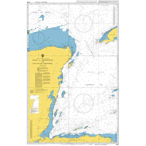
 1220 - Gulf of Honduras and Yucatan Channel
3 × £31.50
1220 - Gulf of Honduras and Yucatan Channel
3 × £31.50 -
×
 3146 - Scotland West Coast Loch Ewe
1 × £31.50
3146 - Scotland West Coast Loch Ewe
1 × £31.50 -
×
 5125(6) - Routeing Chart South Atlantic Ocean - June
1 × £17.73
5125(6) - Routeing Chart South Atlantic Ocean - June
1 × £17.73 -
×
 3850 - Galveston Bay to Ship Shoal
2 × £31.50
3850 - Galveston Bay to Ship Shoal
2 × £31.50 -
×
 1000 - Senegal Approaches to Dakar Baie de Goree
1 × £31.50
1000 - Senegal Approaches to Dakar Baie de Goree
1 × £31.50 -
×
 3140 - St Peter Port
1 × £31.50
3140 - St Peter Port
1 × £31.50 -
×
 NP54 Admiralty Sailing Directions North Sea (West) Pilot
1 × £75.96
NP54 Admiralty Sailing Directions North Sea (West) Pilot
1 × £75.96 -
×
 Marine Radio Flip Cards
1 × £10.00
Marine Radio Flip Cards
1 × £10.00 -
×
5125(11) - Routeing Chart South Atlantic Ocean - November
1 × £17.73
-
×
 1228 - Iraq and Kuwait Umm Qasr Az Zubayr & Approaches
1 × £31.50
1228 - Iraq and Kuwait Umm Qasr Az Zubayr & Approaches
1 × £31.50 -
×
121 - England East Coast Flamborough Head to Withernsea
1 × £31.50
-
×
 NP265 Tidal Stream Atlas of West Coast of France
1 × £20.07
NP265 Tidal Stream Atlas of West Coast of France
1 × £20.07 -
×
 9 - La Skhirra-Gabes and Ghannouch with Approaches
2 × £31.50
9 - La Skhirra-Gabes and Ghannouch with Approaches
2 × £31.50
Subtotal: £1,061.29