-
×
 1194 - Spain South East Coast Cartagena
1 × £37.80
1194 - Spain South East Coast Cartagena
1 × £37.80
Subtotal: £37.80
 1194 - Spain South East Coast Cartagena
1 × £37.80
1194 - Spain South East Coast Cartagena
1 × £37.80 Subtotal: £37.80
£37.80
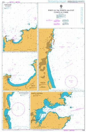
In StockPorts on the North and East Coasts of Corse
Admiralty Chart 1425 Ports on the North and East Coasts of Corse
All our standard charts are corrected to the latest Notices to Mariners and available as POD. Please contact us if you would prefer this in POD (print on demand) format.
| Weight | 0.121 kg |
|---|---|
| Dimensions | 88 cm |
| Edition Date | 22/02/2024 |
| Publisher | UKHO |
| Author | Admiralty |
Mediterranean Sea, Spain – East Coast, Approaches to Barcelona
Mediterranean Sea, Spain – South East Coast, Cartagena
Italy – Sardegna, Oristano and Approaches
Italy, Ports on the North and West Coasts of Sardegna
Mediterranean Sea, Spain – East Coast, Barcelona
Aegean Sea – Greece and Turkey, Steno Kafirea to Rhodes Channel
