-
×
 2658 - Outer Approaches to Mina` al Jeddah (Jiddah)
1 × £37.80
2658 - Outer Approaches to Mina` al Jeddah (Jiddah)
1 × £37.80 -
×
Imray Chart C24 Flamborough Head to Fife Ness
1 × £28.95
Subtotal: £66.75
 2658 - Outer Approaches to Mina` al Jeddah (Jiddah)
1 × £37.80 Imray Chart C24 Flamborough Head to Fife Ness
1 × £28.95
2658 - Outer Approaches to Mina` al Jeddah (Jiddah)
1 × £37.80 Imray Chart C24 Flamborough Head to Fife Ness
1 × £28.95 Subtotal: £66.75
£28.95
In Stock1 in stock (can be backordered)
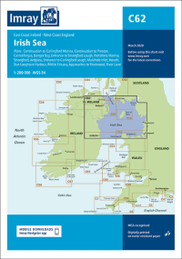
Imray Chart C62 Irish Sea
Scale: 1:280,000 WGS 84
On this March 2020 edition the latest depth surveys have been applied throughout. The latest firing practice areas are shown, as is up to date wind farm information. The chart has had general updating throughout.
Plans included:
Carrickfergus (1:15 000)
Bangor Bay (1:17 500)
Entrance to Strangford Lough (1:37 500)
Portaferry Marina (1:7500)
Strangford (1:5000)
Ardglass (1:15 000)
Entrance to Carlingford Lough (1:26 000)
Malahide Inlet (1:35 000)
Howth (1:12 500)
Dun Laoghaire Harbour (1:15 000)
Ribble Estuary (1:125 000)
Approaches to Fleetwood (1:50 000)
River Lune (1:100 000)
Continuation to Carlingford Marina (1:40 000)
Continuation to Preston (1:125 000)
| Weight | 0.5 kg |
|---|---|
| Dimensions | 30 × 25 × 1 cm |
| Edition Date | Mar-22 |
| Scale | 1:280,000 WGS 84 |
